
THE SOF PARATROOPER AND HIS MAP ON THE 21st CENTURY BATTLEFIELD:
"You fight as you train" on foot and in vehicles...

A GLOBAL SPECIAL OPERATIONS FORCES PRIMER
FOB 910: your www SOF Forward Operating Base
 The surgical precision a 12-man (U.S. Army Special Forces Operational Detachment Alpha or "A" Team) SFOD-A can bring to a target or operational area has been greatly enhanced by Global Positioning Systems (GPSs) that use NAVSTAR satellites to give a precise location fix wherever they are on the earth. You can enter in your starting point into your AN/PSN-11 Precison Lightweight Global Positioning Receiver or "Plugger" and navigate to waypoints and return to exactly where you began. However, this doesn't mean you can tell someone else far away, in a fast-moving aircraft about to drop ordnance, or in a SFOD-B Team where you want the resupply airdrop bundle to be delivered if your map isn't right so they can see where you are IN RELATION TO THE GROUND AS PICTURED BY THE MAPS IN USE.


At the bottom of most maps is a listing of the DATUM the map was drawn to; until the "WGS 84" mathematical computer model of the earth was created, datums were arbitrary points on the earth that map makers used as a starting point. While we used Meade's Ranch in Nebraska for "NAD1927", other countries use different central points. The differances are enough to get you and your men killed, if you do not insure that your map datum is entered into your Plugger during set-up and that all parties operating with you on the mission are working from that same map. Since the entire world has neither been mapped nor converted over to "WGS 84" you must insure your Plugger is in synch with your map you have to work with. Often the DATUM is "NAD 27" which is covered by entering "NAS-C" on your Plugger during set-up.
Next, if your map is an aviation map in 1:250,000 scale or larger, if its a DMA/NIMA map it has Military Grid Reference System (MGRS) lines that can be read with the standard military map protractor (GTA 5-2-12, 1981 COORDINATE SCALE AND PROTRACTOR) but remember that each number you read is 1,000 meters---an entire grid square-----and the tick marks in between can give you at best a 6-digit grid coordinate---though working with the Plugger you can compare its 10-digit MGRS coordinate and eyeball a closer mark on your map. What appears to be one grid square on this scale map is an entire map sheet in 1:50,000 scale. You will need to note the 100,000 meter grid zone identifier letters "GL" "TF" etc. and mention them before you state your 6, 8 or 10-digit grid coordinate. If talking really "long distance" your grid coordinates need to be prefixed by the Universal Transverse Mercator (UTM) Zone you are in, there are 60 zones of 6 degrees west/east with a code letter running north and south until the curve of the earth makes a different map system necessary called Universal Polar System (UPS). Fort Bragg is in 17S for example. A complete grid coordinate might read:
17S GL 12345 67899
WHERE'S MY GRID LINES? WHERE DO I GET A PROTRACTOR?
GPS is only as good as the maps being used with it and the skill of the SOF Soldier at making his ground observations and his tools work in synch. To get the kind of situational awareness and confidence to move tactically or even run into battle without holding a magnetic compass steady for a directional fix by frequent stops will require a rapid terrain-map-GPS reference that is being sought for in a moving map display on the Soldier's helmet for the 21st Century Land Warrior Program. Until then, a "low-tech" version of this could be a Plugger reformatted to fit on the Soldier's forearm via elastic straps so he can peek at the terrain, glance at his Plugger on his arm, then run his finger or eyes over his topographical map for a quick navigational fix. The forearm Plugger should have Longitude/Latitude in degrees, minutes and seconds displayed simultaneously with MGRS/UTM so the Soldier can become proficient with both since some maps only have longitude/lattitude lines. In fact, civilian Magellan and Trimble GPS receivers already have forearm holders made by Navy SEAL Mike Noell's Blackhawk Industries.
Unfortunately, much of the Continental U.S. used by a Force Projection Army to deploy to anywhere in the world by Airborne means is covered only by 1:24,000 and 1:62,000 scale U.S. Geological Survey (USGS) maps when training is conducted off military bases. These maps cannot have grid coordinates plotted accurately because our G.I. map protractor only has 1:25,000-250,000, 1:100,000 and 1:50,000 scale grid readers.
The good news is that some USGS maps have 1,000 meter tick marks on the edge of the map that can by drawn in (I suggest pencil) by the Soldier using a yard stick to create a MGRS. Next a 1:24,000 scale map protractor can be created by photo-copying the distance bar scale on the bottom of the map twice and cutting and pasting 1,000 meters worth into a 90 degree "L" shape to make a map protractor. Write in the numbers 1-1000 and mass produce for your Soldiers, instructing them to cut-out the "L" shape and laminate it so it can be laid over the top of the newly created grid lines to read grid coordinates off of USGS maps. Cut-out a triangle within the lamination so you can plot points within the "L" shape. Your protractor should look just like the G.I. protractor's grid readers. A sample is enclosed on the link below which describes in detail MGRS and how to construct your own 1:24,000 scale map grid reader.
All USGS maps should have a map grid reader on the lower corner so Soldiers can cut it out and use it as a grid reading device. If you wrote to DMA/NIMA at the address below and asked them for this, perhaps future ALL maps including military 1:25,000, 1:50, 000, 1:100,000,1:250,000 maps will have this emergency grid coordinate reader offered on the bottom end of the map sheet.
More ideas that need to be incorporated into NIMA maps
NIMA General Help Desk (L-52)
3200 South Second Street
St. Louis, Mo. 63118-3399
DSN: 490-1236
Toll free: 1-800-455-0899
Commercial: (314) 260-1236
Fax: (314) 260-1128
DSN Fax: 490-1128
e-mail: chdesk@nima.mil
web site: http://www.nima.mil
Remember when using USGS maps to determine what 100,000 meter grid zone you are in as well as what UTM area you are in, which may require a phone call to your map distributor since often this info is not listed on the map!.
FEEDBACK!
"Airborne Equipment Shop,
My name is Tonio DeSorrento. I really love your site and I appreciate what your organization is doing to try to persuade our nation's senior leadership to make the best decisions for our military.I have just started a company that is trying to improve fire support procedures and products in the Army, marines and Air Force. We're based near Ft.Sill, OK. We're very small (two people) and probably won't ever make a profit-but we've already begun making a difference for company- and platoon-level fire supporters. We've rewritten a key handbook, made a better version of a product called the OF fan, and INVENTED a new close air support template (not yet for sale) that allows fire supporters to determine lat/long coordinates off of a UTM/MGRS map at any latitude. (Because those lasers and GPSs don't always work!)Would you consider posting a small link to my website in the corner of one of your pages? Please visit it and decide whether it is compatible with your message:
Thank you for your time, and I hope that we can agree to posting mutual links.
Very respectfully,
Tonio DeSorrento
Partner/Founder, The Universal Observer Company
A PLUGGER WITHOUT CRYPTO IS NO BETTER THAN A CIVILIAN GPS
What many Soldiers may not realize that NAVSTAR satellite signals are scrambled and encrypted. If you do not take the time and effort to download cryptological (codes) into your Plugger it will only give you at best 100 meter accuracy that wavers back and forth. This is not even close to good enough for weapons delivery in proximity to ground troops; the DOD has banned un-encrypted Pluggers, and off-the-shelf civilian GPS systems from surveying drop/landing zones, fire support mission, air strikes etc. yet I see soldiers all the time using these things to set up land navigation courses and its all giving GPS a bad name when you go to a point and its not there or where it should be. Walking into a minefield due to not encrypting your Plugger properly is not a possible outcome.
With encryption, the Plugger will give accuracy down to 8 meters or less. This is what we want and need. Make your chain-of-command realize this by education, obtain the GPS tutorial disks from the sources below and download into your unit's SFODA computers. And reading Section C of your Plugger Technical Manual, TM 11-5825-291-13 that comes with the Plugger.
GPS Tutorial
NSN: 7644-01-417-8307
DMA Stock Number: GPSXXTUTORPACK
Order using MILSTRIP via DAASC, DAMES, DIELOG or DDN.
POC: DAMES: Bill Kelly DSN: 986-5004 Ext 297
COM: (513) 296-5004 Ext 297
DIELOG: Lisa Houston DSN: 986-5681 Ext 213
COM: (513) 296-5681 Ext 213
GPS Plugger Simulator
Same as above.
Or contact the author at his e-mail or mailing address.
Mike Sparks
Or call JPO: (310) 363-6726
Expert Infantryman's Badge (EIB) Plugger station
reocities.com/eib2010/StationG.htm
Point G-5-A
Task 1: Determine Location Using a PLGR
TEST CONDITIONS: Given a PLGR (turned off) with battery (BA-5800/U) not installed, pencil and form for recording grid coordinate.
TEST STANDARDS:
1. Determine the 8-digit coordinate of a predetermined point to within 50 meters of its location. (After 5 minutes, the PLGR defaults to FIX mode when turned on. After 5 minutes, it will automatically switch to STBY at which time it will not be tracking any satellites.)
2. Complete the performance measures within the specified time determined by the EIB board.
SOLDIER'S MANUAL CROSSWALK: This task is based on information located in TM 11-5825-291-13 and TB 11-5825-291-10-2 and is modified for the EIB test with the addition of a time standard.
EQUIPMENT REQUIRED FOR POINT: AN/PSN-11(V) (PLGR), BA-5800/U, LS6-BA, FB Form 20-17-R, field table, pen/pencil.
SITE SETUP: Provide one each PLGR with BA-5800/U battery for each candidate.
INSTRUCTIONS TO CANDIDATES
"Let me have your attention. At this point, you are required to determine location using PLGR. You will determine the 8-digit grid coordinate to your location using the PLGR. When I give the command BEGIN, start the task. Continue until you finish or until I tell you to stop. Do you understand what you must do?"
If there are any questions, you may repeat the instructions but you may not elaborate on what you have read.
"Begin."
Given one each PLGR (turned off) along with a BA-5800/U battery.
Insert the BA-5800/U battery well located on top left side of the PLGR. (Place the plus and minus side of the battery in first to ensure it makes contact with the bottom of the battery well.)
Turn on PLGR(press ON/BRT key) (wait for it to go through its BIT which consist of four screens).
Press MENU key.
Move cursor to SETUP.
Activate by pushing DOWN arrow key.
On page 1, press RIGHT arrow key twice.
(SV-TYPE is blinking.)
Press DOWN arrow key until mixed is blinking.
Press RIGHT arrow key once.
Press DOWN arrow key four times.
Press RIGHT arrow key once.
(SETUP DTM is blinking.)
Press UP or DOWN arrow key until key until NAS-C (Or the Datum the EIB test maps are using) is blinking.
Press POS key.
Press DOWN arrow key until TRACK/SEARCH appears at top of the screen.
Observe screen until the PLGR is tracking at least three satellite vehicles.
Once the PLGR is tracking three or more satellite vehicles, press UP or DOWN arrow key two times to get the grid coordinates from the third line of PLGR and write these coordinates down on the form provided. (Ensure you include the two-letter 100,000 meter square identifier.)
Given one PLGR with battery. Place the battery into the PLGR and turns the set on. Once the PLGR has completed its BIT (BUILT-IN TEST), set up the PLGR. In the setup phase, ensure the PLGR is set up for the proper DATUM (NAS-C for Ft. Benning's DMA/NIMA maps for example). You can change the SV-TYPE from ALL-Y to "Mixed", it is your option. "Mixed" means that the PLGR can track satellites quicker. Once you have the proper set up, go to POS to ensure the PLGR is tracking at least three satellites. Then come up with the required 8-digit grid coordinate.
NOTES:
1. After each candidate has finished, he goes into the set-up mode and changes the set-up datum to something other than the correct DATUM (NAS-C for Ft. Benning, Ga maps). Use the same selected wrong DATUM for each candidate.
2. Ensure that the ALM AGE is one day.
3. Make sure the candidate has the grid coordinates on the screen, and in the top right corner of that screen, he has the meter reading NOT OLD.
4. Have spare PLGRs on hand.
5. Ensure crypto variables are loaded into the PLGR.
6. Have extra BA-5800/U batteries.
Ordering Plugger Crypto:
U.S. Army Communications Security Logistics Agency (CSLA)
POC: Mrs Susan Krausman DSN: 879:6709
COM: (602) 538-6709
FAX: Unclass: DSN: 879-7048
Secure: DSN: 879:7043
CDR
USACCSLA/SELCL-KPD-KEY
Ft Huachuca, AZ 85613-7090
BATTERIES, BATTERIES, BATTERIES
The "Achilles Heel" of our high-tech Army is its voracious appetite for batteries. The Plugger uses a peculiar hot-dog sized non-rechargeable, lithium battery called the BA-5800. Prepare to in a field environment or in a country away from U.S. logistical support to use AA batteries via the WB101 holder (Rockwell #221-01-0135-020) that can be ordered from the Plugger maker. You are more likely to find (WB101) AA batteries in Africa then a BA-5800.
Rockwell Collins Avionic & Communications division
350 Collins Rd. NE
Cedar Rapids, IA 52498-0120
Phone: 1-800 321-295-4777
(319) 395-4777
E-mail:cacd@cacd.rockwell.com
Web site: http://www.cacd.rockwell.com
POCs: Tim Jenson, Michael Legg, Chris Zeihr
MOUNTED LAND NAVIGATION: NO TIME TO GET LOST
GRENADA, 1983: Stumbling into trouble with an unarmored vehicle
To Fight with Intrepidity by LTC John Lock, U.S. Army, pages 462-463
"Gun jeep Team 5 of 'A' Company, 1st Battalion under the command of Sergeant Randy Cline, reported to their company commandersoon after the team's arrival on the island. directed to take his 5 man team to secure a road junction two hundred meters north of the True Blue campus just forward of the company's position.; Cline and his men missed spotting the campus, which was hidden in a shallow point below ground level. Realizing they were not in the right location, cline attempted to match the terrain and trails around them with those found on the map. But the map was of little help, for it did not reflect the majority of the trails in the area. continuing to search for the intersection, the team drove well into the area held by a PRA company.
The PRA company had established an ambush site eight hundred meters northwest of True Blue. Cline and his team had already driven through it once but the enemy had not reacted. Turning around, Cline and his men were not so lucky the second time. Concealed in bushes and shallow trenches, the PRA opened with a heavy volume of fire at close range on the swiftly moving jeep. Though surprised, Cline and his fellow Rangers were able to return fire with their M16 rifles and the jeep's M60 machine gun, killing at least one of their ambushers. But the remaining ambushers were able to destroy the Ranger's vehicle and kill Cline and three of his fellow Rangers-Privates Martin Maynard, Mark Rademacher, and Russell Robinson. the only Ranger to escape the ambush was Private Timothy Domick, who was able to make his way back to his company despite his wounds."
AAR:
1. GPS is a must, realize maps are not perfect however
2. Bullet-caliber resistant body armor is a must
3. Vehicle armor is a must
4. Know your CO's intent: if he wanted an intersection roadblock, any of the ones encountered would have sufficed, achieving his INTENT---be flexible
5. Do a map recon: how far ahead is the road junction? How many minutes driving time is this from the SP? Is the True Blue Campus as a landmark visible from the road? If not, how far is it from our company's position? Dismount and scout for the True Blue campus after the odometer reads they have traveled X amount of time
6. Use the vehicle odometer for land navigation! they ended up 800 meters beyond True Blue instead of 200
7. Be more cautious when moving into enemy terrain with an unarmored vehicle!!!! Be SURE!

Land Navigation in a vehicle is a lot more difficult than on foot because you are moving very fast and need to know exactly where you are going. Terrain association on the move can be difficult or impossible if your maps are not accurate. GPS can greatly help IF you can get it to work inside your vehicle. If you are inside an Armored Fighting Vehicle (SF, advising foreign armies in the Coalition Warfare --CW mission), you are enclosed in a metal box sure to block a clear signal from GPS Satellites.
The way to get a clear GPS signal is to mount an antenna on the OUTSIDE of your vehicle  and run a cable
 into the GPS receiver which the Soldier Navigator can monitor and compare with his map and the surrounding terrain. The vehicle driver keeps an odometer count that is passed back to the navigator who plots the vehicle position on the map as it moves. The Navigator can intercom in phase lines/check points as they are crossed etc.
In the Bradley Fighting Vehicle (BFV) there are unused side firing ports that the GPS cable can be easily run out of.

Mount the antenna by attaching the Mighty Mouse antenna magnet to the steel side plate or top cargo hatch hinge plate or gluing a piece of velcro to the back deck roof and to the Plugger's remote antenna (NSN 013-1925-030) bottom. Use the right rear firing port (if you use older model BFVs) and route its cable (NSN 426-0141-050) back to the right rear seat where the dismount Assistant Squad Leader (ASL) sits. Use 100 mph tape or velcro strips to secure the cable to the side of the BFV. The ASL should glue a piece of velcro to the bottom of his GPS receiver and the left side of his map case, so he can view both at the same time. The ASL should wear a CVC helmet so he can send in navigation reports back to the Bradley Commander (BC) in the turret. Then, when he dismounts he knows where he is at ("Situational awareness") and takes the GPS receiver along with him to enable him to aggressively fight on foot sure as to where he is at at all times.
MOVING MAP DISPLAY, 007?
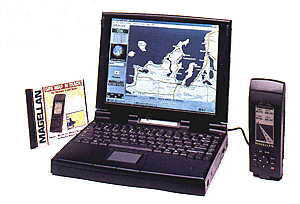
In 1963, the James Bond film, Goldfinger had agent 007 driving a sports car with an electronic map that had a dot representing his position on it and the car he was following which he had placed a miniature homing beacon on. Ironically, 36 years later GPS has made the moving map a reality not a movie speculation. You could take a laptop, battery-operated Personal Computer (PC) with GPS map software an connect to your GPS receiver in your AFV and get an electronic moving map display. Doing this with the G.I. Plugger would cost you or your unit a fortune, but its possible. If you are in a welfare-recipient reactive mode (you will not do anything to improve your equipment readiness unless Uncle Sam issues it to you) it may be years before you will ever have this capability.
Instead of such defeatism, I suggest you buy a civilian GPS with MGRS capability, a Mighty Mouse remote antenna to achieve a hand held map interface. This is a magnetic dome antenna that will stick to the AFV without need of velcro except for its remote cable.
My suggestions:

The Magellen tracker will fit nicely into a M16 magazine pouch and you can connect a mini-carabiner clip to its lanyard to "dummy cord" it to your belt or ETLBV.


Now then, if you are really BOLD, get a lap top PC and your choice of the following software if you want a moving map display:
In fact, there are programs that will give you a situational awareness "mission preview" of the terrain you are going into:
Yes, they are civilian GPS and not as accurate as the military's PLUGGER, but they are far better than nothing at all! In a mounted land navigation situation YOU MUST KNOW where you are! Otherwise you run the risk of driving into a minefield and/or ambush. You do not have the luxury in a vehicle of deliberate, careful, and risk-free map analysis that you could render during foot movement. Your "Boyd decision-making cycle" is very small in a moving vehicle.
MORE REALISTIC TRAINING: THE PAY-OFF
The end result of getting our USGS maps equipped with MGRS lines, correct protractors, our Pluggers set properly with the right DATUM, and encrypted with 8 meter accuracy is more realistic training NOW here in CONUS. It means a greater understanding of the world we live in and fight for, and how it is mapped so we can deliver precise, accurate weapons effects and/or life-saving humanitarean and nation building helps in a timely manner. The world moves by the speed of the AIR, since 100% of the earth is covered by AIR , with terrain-map-GPS situational awareness we can reach to any spot on the globe within hours to save the day.
Today's world moves by the speed of air and is linked together by instant space-based observation means. It is entirely likely that a unit in deepest, darkest Africa could be sending a message by TACSAT all the way back to the continental United States. For them to know exactly where you are, you are going to have to tell them. You have to tell them exactly what UTM grid zone you're in, 100,000 meter grid zone identifier you are in before you send over numeric 4, 6, 8, or 10 digit grid coordinate. From this information a flight of C-17 Globemaster III full of Paratroopers, M113A3 Gavins, other light AFVs, human powered vehicles, ammunition, MREs and supplies could be there in a matter of hours. Or it could be a Paratroopers link up where you want them to and not on your head. You cannot expect a pilot flying seconds away from diving into the ground to double-check your map work. And as the recent USAF B-52H friendly-fire accident in Afghanistan that killed three 5th SFG (A) Soldiers reveals, safety precautions like not being danger close (less than 600 meters) to where precision munitions will drop, insuring delivery aircraft tracks are not inline with friendly troops, wearing helmets, body armor or being in a light tracked armored fighting vehicle are still prudent (even if not part of the "SF foot-commando image") when dropping Inertial Navigation System (INS) and GPS guided ordnance like JDAMs. Better Close Air Support (CAS) is also effected by lower-flying A-10 and AH-64 aircraft that can be visually controlled by SF ground troops rather than a high-flying B-52H at 40,000 feet, though the latter based at Barksdale AFB in Louisiana should be used for live-fire exercises at nearby U.S. Army Fort Polk to hone air/ground tactical bombing skills of Army Soldiers and not just rely on attached USAF Combat Control Teams. AFSOC aquiring some A-10s to function as modern-day A-1 SkyRaider equivalents to support SF troops on the ground with safe CAS is a good idea if the regular AF plans on retiring them.
How to use Plugger to call-for-fire:
http://call.army.mil/call/ctc_bull/96-10/chp4.htm
"The Global Positioning System also provides unique capabilities to the services not envisioned when the first GPS satellites were launched 20 years ago. GPS was originally designed to provide 24-hour navigation services, which it does well, but is now also used to deliver precision-guided munitions.""This new generation of smart weapons will save lives,"
Maj. Gen. Gerald F. Perryman Jr., who commands AFSPC's warfighting arm -- 14th Air Force adds:
"Our pilots are no longer tied to their target ... they can 'fire and forget' thanks to the accuracy provided by GPS targeting and guidance systems. New, precision-guided munitions allow one pilot on a single pass to take out several targets. This makes space technology a real force multiplier -- it allows us to send fewer people to do the same job."
Perryman pointed out the 24-satellite GPS constellation is also a neutralizer of traditionally bothersome environmental factors.
"The Navy's Tomahawk cruise missile can fly day or night, in rain and fog, or through heavy battlefield smoke due in a large part to GPS...Although space is critical to winning any battle today, many times that fact is forgotten"
De Opresso Liber!
1st TSG (ABN)
PO Box 73253
Ft. Bragg, NC 28307-3253
FEEDBACK!
"Dear People,
Noting that your webpage located at:
http://www.geocities.com/Pentagon/7963/plugger.html
discusses GPS grids in some detail, I offer you my thoughts on the matter located in the wegpage
www.cs.nmsu.edu/~jbj/index_grid.htm
This material was generated as a result of my noting two flaws in the definition of the original UTM system, and then realizing that the dual-letter designations introduced in the U.S. Military Grid Reference System (MGRS) were not readily computable or interpretible by humans in the field.
Once I discovered a means to define and construct a wide spectrum of metric grids, I decided to place on my website not only many such grids but also an exposition of GPS grids in general.
Thanks for providing the public with your website.
Respectfully yours,
John
John B. Johnston
johnstonjohnb@qwest.net
http://www.cs.nmsu.edu/~jbj
Return to Paratrooper 2000, click on M4 5.56mm Carbine with M203 40mm grenade launcher